
Article brief
Exploring Hanoi can feel like stepping into a living museum.
Route flow, hotel placement and transfer timing are the three decisions that shape the whole trip.
Exploring Hanoi can feel like stepping into a living museum. With its narrow alleyways, tree-lined boulevards, lakes, and centuries-old temples, the city rewards travelers who come prepared. A well-designed Hanoi City Sightseeing Map is more than a navigation tool — it’s your key to understanding how history, culture, and daily life connect across the capital.
Whether this is your first time in Vietnam or a return visit, using a reliable Hanoi sightseeing map for tourists helps you save time, avoid unnecessary detours, and focus on what truly matters: meaningful experiences.
Why a Hanoi City Sightseeing Map Matters
Hanoi is compact, yet layered. Ancient quarters sit beside colonial villas, while modern cafes appear next to sacred pagodas. Without a clear Hanoi tourist attractions map, many visitors miss key sites or underestimate travel time between neighborhoods.
- Plan realistic walking or cycling routes
- Group nearby attractions efficiently
- Understand which areas suit your travel style
- Avoid peak traffic zones at rush hours
If you enjoy independent exploration, a sightseeing map gives you confidence. If you prefer expert guidance, it helps you choose the right Hanoi city tour that matches your interests.
“Hanoi isn’t about ticking boxes — it’s about connecting the dots between places, people, and stories.”
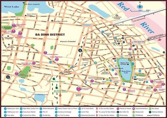
Understanding Hanoi’s City Layout
A good Hanoi city map attractions layout usually divides the city into clear sightseeing zones. Knowing these zones helps you decide where to spend your energy and time.
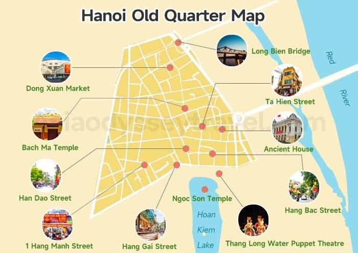
Hanoi Old Quarter – The Cultural Heart
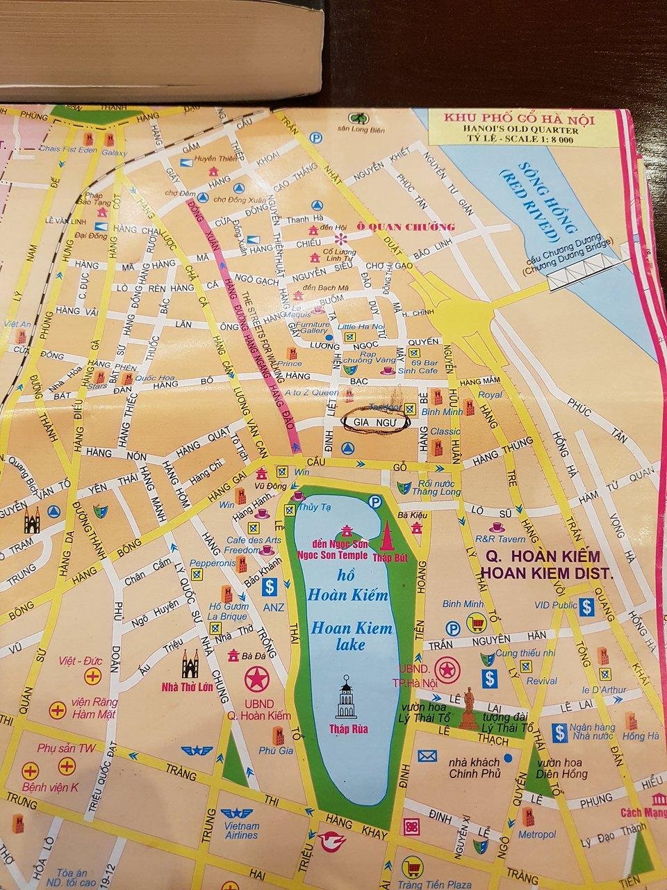
The Old Quarter is often the starting point on any Hanoi City Sightseeing Map. Its 36 historic streets surround Hoan Kiem Lake and reflect traditional trade villages.
Here, distances are short, making it ideal for walking tours like the
Hanoi Old Quarter walking tour.
French Quarter – Colonial Elegance
South of the Old Quarter lies the French Quarter, easily identified on any Hanoi travel map by its wide boulevards and European-style architecture.
Key landmarks here include the Opera House, museums, and leafy streets perfect for slow exploration. This area pairs well with a
French Quarter Hanoi walking tour.
Ba Dinh District – History & Identity
Ba Dinh is the political and historical center of Vietnam. On a Hanoi tourist attractions map, this district stands out for its wide spaces and national landmarks.
- Ho Chi Minh Mausoleum
- Presidential Palace area
- One Pillar Pagoda
For historical accuracy and context, you can cross-check information with reputable sources like the
Vietnam National Administration of Tourism.
Top Attractions Marked on a Hanoi City Sightseeing Map
A practical Hanoi City Sightseeing Map doesn’t overwhelm you with pins. Instead, it highlights must-see landmarks and shows how they connect logically.
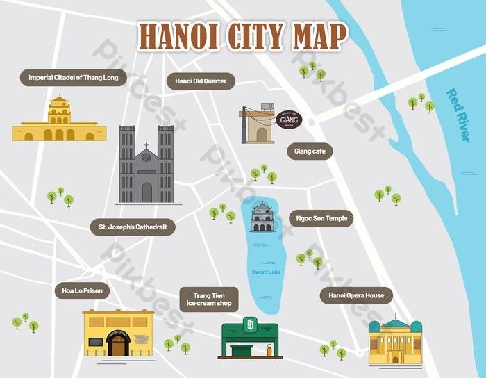
Hoan Kiem Lake & Ngoc Son Temple
Located at the intersection of old and new Hanoi, Hoan Kiem Lake is usually the visual anchor of any map. Early mornings and evenings are ideal for walking here.
If you’re short on time, this area combines well with a
Hanoi city walking tour.
Temple of Literature
Marked slightly west of the Old Quarter, the Temple of Literature represents Vietnam’s scholarly heritage. Its calm courtyards offer a peaceful contrast to busy streets.
UNESCO also recognizes Hanoi’s long educational traditions, which you can explore further via
UNESCO cultural heritage resources.
Using the Map Based on Your Travel Style
Not all travelers explore Hanoi the same way. A smart Hanoi sightseeing map for tourists adapts to different interests.
- First-time visitors: Focus on Old Quarter, Hoan Kiem Lake, Ba Dinh
- Active travelers: Combine walking with cycling routes
- Families: Choose open spaces and museums
For example, cyclists may enjoy routes suggested in the
Hanoi cycling tour, which avoids congested roads.
Friendly Tip Before You Continue Planning
In the next part of this guide, we’ll explore transport routes, digital vs printable maps, and ready-made itineraries. If you already feel inspired, you can:
Book a Hanoi sightseeing tour
Contact our local travel experts
Have you used a city map to explore Hanoi before? Share your experience in the comments — your tips might help fellow travelers plan a better journey.
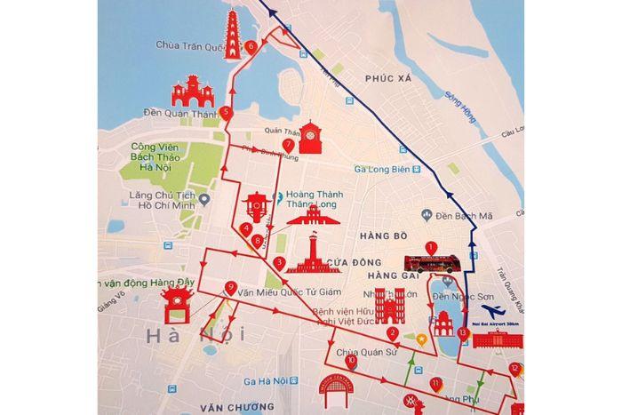
Public Transport & Navigation on a Hanoi City Sightseeing Map
A well-designed Hanoi City Sightseeing Map doesn’t just show landmarks — it helps you move between them smoothly. Hanoi’s transport system is improving every year, and knowing how it appears on a Hanoi travel map can save you both time and energy.
Bus Routes & Tourist-Friendly Lines
Public buses are clearly marked on many digital maps and are one of the most budget-friendly ways to explore the city. Key routes connect the Old Quarter with Ba Dinh, West Lake, and major museums.
- Cheap and reliable for longer distances
- Best for travelers staying more than 2 days
- Air-conditioned on most routes
For official route updates, check the
Hanoi Department of Transport.
Cyclo & Electric Car Routes
On many Hanoi sightseeing maps for tourists, you’ll see suggested cyclo and electric car paths around Hoan Kiem Lake and the Old Quarter. These slow-paced options are ideal for first-time visitors.
If you want a guided experience without walking too much, the
Hanoi cyclo tour is a relaxed way to understand the city.

Digital vs Printable Hanoi City Maps
Travelers often ask whether digital or printed maps are better. The answer depends on your travel style. A smart Hanoi City Sightseeing Map strategy often combines both.
Digital Maps & Mobile Apps
Google Maps works well in Hanoi, especially for cafes, walking routes, and real-time traffic. Digital maps are perfect for spontaneous explorers.
You can compare locations and reviews via
Google Maps, especially when choosing restaurants or museums.
Printable Tourist Maps
Printed maps remain useful in areas with weak internet or when you want a big-picture view of the city. Hotels and visitor centers often provide them for free.
“A printed map helps you see connections you might miss on a small screen.”
Suggested Routes Using a Hanoi City Sightseeing Map
One of the biggest advantages of a Hanoi tourist attractions map is route planning. Below are two practical examples.
1-Day Hanoi Sightseeing Route
- Morning walk around Hoan Kiem Lake
- Explore the Old Quarter streets
- Lunch with local cuisine
- Afternoon visit to Temple of Literature
- Evening food tour or night walk
This route works perfectly with the
One day in Hanoi guide.
2-Day Cultural Exploration Route
- Day 1: Old Quarter + French Quarter
- Day 2: Ba Dinh District + West Lake
For a deeper experience, combine this plan with the
2 days in Hanoi itinerary.
Helpful Tips for Using a Hanoi City Sightseeing Map
- Start early to avoid traffic and heat
- Group attractions by district
- Leave buffer time for coffee breaks
- Always carry a backup offline map
Hanoi is safe, but walking awareness matters. You can read more official travel advice at
Lonely Planet Hanoi.
Self-Guided Exploration vs Guided Tours
Some travelers love the freedom of a map, while others prefer expert storytelling. There’s no wrong choice.
- Self-guided: Flexible, slow-paced, personal
- Guided tours: Deeper context, hidden stories
If you want a balanced option, explore our
Hanoi guided tours, designed for small groups and cultural depth.
Where to Get a Reliable Hanoi City Sightseeing Map
You can find trustworthy maps at hotels, visitor centers, or directly through local travel experts. Vietnam Travelers also provides route-based maps tailored to real travel experiences.
Explore Hanoi city sightseeing experiences
Frequently Asked Questions
Is Hanoi easy to explore with a map?
Yes. With a clear Hanoi City Sightseeing Map, most central attractions are walkable and well signposted.
Should I rely only on Google Maps?
Google Maps is helpful, but combining it with a tourist-focused map gives better cultural context.
How many days do I need in Hanoi?
Two to three days is ideal for first-time visitors, depending on pace and interests.
Final Thoughts: Explore Smarter with a Hanoi City Sightseeing Map
A thoughtfully used Hanoi City Sightseeing Map helps you explore confidently, travel responsibly, and connect more deeply with the city. It’s not about seeing everything — it’s about seeing what matters to you.
Ready to start planning?
Discover Hanoi highlights
Contact Vietnam Travelers for personalized advice
We’d love to hear from you. What’s the first place you’d mark on your Hanoi map? Leave a comment, share your thoughts, or ask us a question — let’s explore Hanoi together.